Tri-County Standards For Surveys And Plat Maps
Clackamas, Multnomah and Washington Counties
Download a
The following standards for surveys and plats are intended to clarify and supplement ORS 92 and ORS 209.250. All additional information required by ORS 92, ORS 209.250, Oregon Administrative Rules, or local ordinances or regulations shall be included on all surveys and plats submitted for review or filing.
Survey/Plat size — 18 x 24 inch ONLY.
A minimum border of one-half (1/2) inch is required for surveys and one (1) inch for plats.
The boundary of the survey or plat shall be a SOLID BOLD line completely around the property being surveyed or platted. The dimensions (bearings & distances) associated with the perimeter line shall be bolded.
Standard engineering scales of 1 inch = 10, 20, 30, 40, 50, 60 or 100 feet shall be used. 1 inch = 200 feet may be used with specific approval of the County Surveyor having jurisdiction. The choice of the scale, from the list above, is subject to the need to be able to clearly depict the information on the map.
The lettering on the map shall be of such size and type as to be clearly legible. The minimum size for upper case letters is 0.08 inches and 0.10 inches for lower case letters. Without approval of the County Surveyor, shading and cross hatching is not allowed. Font size and line weight must be compatible to the extent that it is clearly reproducible. Fine, narrow, line weights do not scan well. Light density line work is unacceptable; all elements of the drawing must be black, not grey.
Unless specifically pre-approved on an individual basis by the County Surveyor, surveys and plats submitted for filing will be of a permanent nature and plotted on polyester film ("Mylar”) with permanent ink that cannot smear or rub off, or white opaque white matte (polypropylene), some counties are now accepting acid free paper maps (Check with the County you are filing in). Mylar plats or surveys that appear to be produced by an electrostatic process using toner are unacceptable. If it has a raised surface (embossed feel) it will be rejected. If in doubt about the stability of the document we will err on the side of caution and reject anything that can be smeared or appears that it may transfer to other documents during storage.
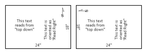
Survey and Plat maps shall be drawn with the text in “Read Right" format. “Read Right” means that all information on the map reads from the top down and then from the left to right. While it is desirable to have the north arrow point to the top or to the left of the page, sometimes that is not possible. In those cases approval from the county surveyor shall be obtained and the text should maintain the “Read Right” orientation. A simplistic drawing is shown below for your use. If you have any questions regarding this policy, contact your specific County Surveyor before preparing the map.
All signatures on surveys and plats shall be “permanent black ink”.
A survey map shall be submitted for filing within 45 days of the setting of the first monument, not 45 days after completion of the survey. The filing of the survey is not contingent upon your receipt of payment for services.
Do not place “Post-it” or other sticky notes on Mylars. Mylars contaminated by adhesives or any other material will be rejected. Mylars that have been scratched or have had the matte damaged are subject to rejection. No rubber ink stamps are allowed on Mylar survey or plat maps. Notary crimp stamps are not allowed.
When a record of survey is submitted for a Property Line Adjustment (PLA), the recorded document number(s) describing the adjusted and/or consolidated boundary(s) shall be shown.